Seeley Creek Fire

Seeley Creek Fire
![]() Admin Sat 30 Jun 2012, 1:03 pm
Admin Sat 30 Jun 2012, 1:03 pm
June 30, 2012
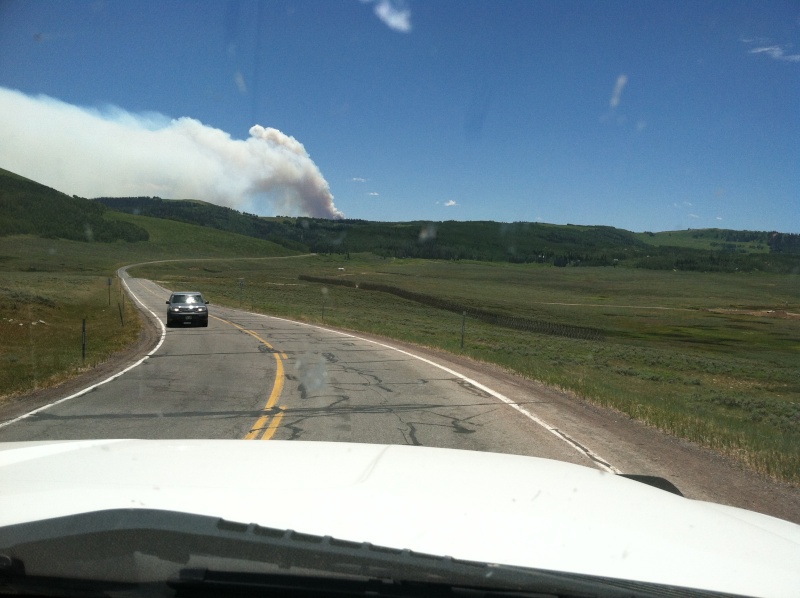
My son Chad & I were able to gain access to our properly yesterday. We had to check in with the Sanpete County Sherriffs road-block checkpoint that is located at the top of Fairview Canyon where SR-264 junctions with SR-31. All we had to do was give our names, property location & Lot # along with the purpose of our visit. We were instructed that we had to be out before dark & check out with them before returning down Fairview Canyon. We were given specific instructions that we could not go down to Schofield via SR-264 and must return via Fairview. We were told that this process to gain access to the SPOA property will remain in effect until the Sanpete County Sherriff is informed otherwise.
After taking care of tasks we wanted to do at our cabin, we checked out at the checkpoint and drove back to Fairview and on to Price where we attended a meeting that was conducted by the combined efforts of the US National Forest, State of Utah DNR and Carbon County. Below is a brief summary of what we heard and is our interpretation by attending that meeting:
As of yesterday morning the Seeley Fire has burned approximately 20,000 acres and is about 2 miles south of the Electric Lake Dam. It is burning on both sides of SR-31.
A type 2 Fire fighting Team arrived on site yesterday & took over the management of the Seeley Fire. This team is the Eastern AZ Incident Management Team. All Great Basin Teams are actively dispatched to other fires in Utah and is the reason the AZ team was dispatched to the Seeley Fire.
The effort to fight this fire is a total suppression effort. No area within the fire area has been or will be deemed as a let burn area.
Seven helicopters will now be used to drop water to fight the fire along with occasional air tankers that will drop fire retardant as needed. Helicopter drops will be the major method to suppress this fire due to the rugged terrain.
Ground fighting efforts will take place as needed to the degree that it can be done in a safe manner for firefighters.
Multiple engines & ground firefighting crews will be used where possible to fight the fire in order to save structures. These crews will be assigned to specific structures that are deemed possible to save by safe firefighting efforts.
There is a mandatory evacuation order in place for Clear Creek and Schofield.
SR-96 from US Hwy 6 to Schofield is closed & will remain closed until the evacuation order is lifted. Residents of Clear Creek and Schofield will be escorted into their property & escorted back out for the purpose of quickly removing heirlooms, boats, trailers, ATVs, snowmobiles, etc. that may be removed quickly (approx. 15 minutes at property). Escort trips must be arranged for in advance of showing up at the roadblock on US Hwy 6. Escort appointments must be made thru the Carbon County Sherriffs office. There will not be any escort trips allowed to the SPOA property thru Schofield. The only access to SPOA property will be from the Fairview (Sanpete County) side.
The Skyline & Horizon mines are closed until further notice.
Road closures & evacuation orders are the responsibility of the respective Counties & the State of Utah. The Type 2 Firefighting/Incident Team does not have authority to open or close roads.
There was no mention in the formal portion of the meeting about anything pertaining to Sanpete County and there was no official representation from Sanpete County at this meeting. However, after the formal meeting presentation concluded, there were several breakout stations where questions could be asked of the respective organization personnel. I was able to confirm that Sanpete County has identified the locations of the various subdivisions in Sanpete County such as Gooseberry Canyons (SPOA) and Fairview Lakes so that if it becomes necessary to have ground crews there to fight the fire the Type 2 Team will do so.
The best news from all of this is that the Type 2 Team is optimistic that it can establish a northern perimeter & contain the Seeley Fires march northward at some ridges south of Electric Lake. This optimism is contingent upon having cooperative weather with the prevailing winds continuing from the S & SW. The fire is obviously still in the hands of Mother Nature to the greatest degree. However, if the projections for weather patterns & firefighting efforts play out as expected then the authorities involved with the firefighting efforts do not believe that the fire will reach our SPOA property.
Again, I would recommend that you take whatever measures you feel are appropriate for your respective property ASAP since there is no guarantee how this Seeley Fire will ultimately behave. The Type 2 Team Manager did term the Seeley Fire as an Angry Fire that demands the highest respect for safety of all involved because it has all of the potential to behave in a very erratic way and its behavior will definitely be affected by changes in the weather.
I hope this helps each of you in some way to at least have more knowledge & be better informed.
Best regards,
Jeff Thomsen
Skyline Association Board President

Admin- Admin
- Posts : 30
Join date : 2008-06-20
Location : Herriman Utah -

Re: Seeley Creek Fire
![]() Admin Sat 30 Jun 2012, 1:06 pm
Admin Sat 30 Jun 2012, 1:06 pm
Admin- Admin
- Posts : 30
Join date : 2008-06-20
Location : Herriman Utah -
Pictures
![]() Admin Sat 30 Jun 2012, 1:17 pm
Admin Sat 30 Jun 2012, 1:17 pm


We did see one Fire fighting plane pass over our cabin while we were there.


Admin- Admin
- Posts : 30
Join date : 2008-06-20
Location : Herriman Utah -
6-30-12 Update
![]() Jeff Thomsen Sat 30 Jun 2012, 2:34 pm
Jeff Thomsen Sat 30 Jun 2012, 2:34 pm
Below is the latest update I received from the Fire Management Team
Regards,
Jeff Thomsen
Date started: Tuesday, 6/26/2012 5:30 a.m. Number of personnel: 268
Location: 15 miles NW of Huntington, Utah Equipment: 22 engines
Cause: Dry Lightning Aircraft: 3 helicopters
Size: 19,700 acres Hand Crews: 5 (20-person each)
Percent contained: 0% Estimated containment date: none
Injuries to date: none Cost to date: $608,655
Property threatened: Evacuated Communities, recreation facilities, guard stations, communication towers, utility lines, gas lines, coal mining facilities. No structures have been lost. Structure protection in place.
Fire Activity:
Incident Commander John Philbins Eastern Arizona Incident Management Team has taken command of this fire, bringing with them additional resources to supplement the local firefighters effort. A structure protection group and an air attack group are in place on the fire. More handcrews and aircraft to support them are on order. Extreme drought conditions, bark-beetle-killed trees, strong gusty and unpredictable winds are still driving the fire. Smoke conditions and directions continue to vary with the changing winds throughout the day and continuing overnight.
Significant Events:
Full suppression strategy continues on all fronts of this fire, and structure protection measures continue to hold. Crews have secured utility lines, gas lines and coal mining infrastructure within the fire perimeter.
Closures/Evacuations/Advisories:
Road closures include: SR-31 at Cleveland Reservoir and at Crandall Canyon. SR-284 at Electric Lake. SR-96 at SR-6. Fish Creek and Bear Ridge Roads at Scofield. No Forest Service Area Closure.
Evacuation areas include: Electric Lake, Scofield, Clear Creek, Hiawatha and several youth camps. A major oil and gas field has been shut down, and several working coal mines have been shut down, causing a hardship to the entire community. Carbon County Sheriffs office is coordinating escorted visits into evacuation areas for immediate needs, please call 435-636-3746 for appointments.
Jeff Thomsen- Posts : 4
Join date : 2012-06-30
Re: Seeley Creek Fire
![]() Jeff Thomsen Sun 01 Jul 2012, 7:38 pm
Jeff Thomsen Sun 01 Jul 2012, 7:38 pm
Regards,
Jeff Thomsen
Eastern Arizona Incident Management Team
For Immediate ReleaseFire Information Call Center: 435-687-3030
8:30 a.m. July 1, 2012Media Calls at EOC: 435-636-3761
Evacuees please call Carbon County
Evacuation Coordinator: 435-636-3746
SEELEY Fire Update
Fire Facts
Date started: Tuesday, 6/26/2012 5:30 a.m.
Number of personnel: 379 (from all over the country)
Location: 15 miles NW of Huntington, Utah
Equipment: 19 engines
Cause: Dry Lightning
Aircraft: 8 helicopters (more on order)
Size: 20,175 acres
Hand Crews: 8 (20-person each)
Percent contained: 5 %
Estimated containment date: none
Injuries to date: none
Cost to date: $1,082,472
Complexity of Incident: John Philbins Eastern Arizona Type-2 Interagency Incident Management Team
Property threatened: Several evacuated communities, 45 residences, recreation facilities, guard stations, communication towers, utility lines, gas lines, coal mining facilities. Structure protection crews are in place. No structures have been lost on this fire. Weather pattern projected to carry fire to the Northeast & South.
Fire Activity:
Increased fire behavior took place in the heavy 20-30 tons/acre bug-kill down dead timber on the southeast perimeter of the fire yesterday afternoon. Firefighters observed 200 flame lengths, fire whorls, and ½ mile spotting. Night shift crews provided structure protection for the evacuated town of Hiawatha.
Additional firefighting resources continue to arrive from around the country to fill requests for assistance. A Structure Protection Group and an Air Attack Group are in place on the fire. More handcrews and aircraft to support them are on order. Extreme drought conditions, bark-beetle-killed trees, strong gusty and unpredictable winds are still driving the fire. Smoke conditions and smoke plume directions continue to vary with the changing winds throughout the day and continuing overnight.
Significant Events:
The full suppression strategy that has been in place from the beginning will continue on all fronts of this fire. Structure protection measures continue to hold, and no structures have been burned. Crews have secured utility lines, gas lines and coal mining infrastructure within the fire perimeter.
Closures/Evacuations/Advisories:
Road closures include: SR-31 at Cleveland Reservoir and at Crandall Canyon. SR-284 at Electric Lake. SR-96 at SR-6. Fish Creek and Bear Ridge Roads at Scofield. No Forest Service Area Closure.
Evacuation areas include: Electric Lake, Scofield, Clear Creek, Hiawatha and several youth camps. A major oil and gas field has been shut down, and several working coal mines have been shut down, causing a hardship to the entire community. Carbon County Sheriffs office is coordinating escorted visits into evacuation areas for immediate needs, please call 435-636-3746 for appointments.
Jeff Thomsen- Posts : 4
Join date : 2012-06-30
Road Closure
![]() tysont20 Tue 03 Jul 2012, 4:27 pm
tysont20 Tue 03 Jul 2012, 4:27 pm
tysont20- Posts : 4
Join date : 2012-07-03
Re: Seeley Creek Fire
![]() Admin Tue 03 Jul 2012, 5:32 pm
Admin Tue 03 Jul 2012, 5:32 pm
Anybody else wish there was an East/West connecting road yet?

Admin- Admin
- Posts : 30
Join date : 2008-06-20
Location : Herriman Utah -
Road Closure
![]() tysont20 Tue 03 Jul 2012, 5:48 pm
tysont20 Tue 03 Jul 2012, 5:48 pm
tysont20- Posts : 4
Join date : 2012-07-03
Re: Seeley Creek Fire
![]() Admin Tue 03 Jul 2012, 6:45 pm
Admin Tue 03 Jul 2012, 6:45 pm
Admin- Admin
- Posts : 30
Join date : 2008-06-20
Location : Herriman Utah -
Re: Seeley Creek Fire
![]() Admin Wed 04 Jul 2012, 12:22 am
Admin Wed 04 Jul 2012, 12:22 am
Let's hope and pray it doesn't reach us.
Good luck to us all.
Admin- Admin
- Posts : 30
Join date : 2008-06-20
Location : Herriman Utah -
Re: Seeley Creek Fire
![]() Admin Wed 04 Jul 2012, 1:14 am
Admin Wed 04 Jul 2012, 1:14 am
Thanks
Admin- Admin
- Posts : 30
Join date : 2008-06-20
Location : Herriman Utah -
Re: Seeley Creek Fire
![]() tysont20 Wed 04 Jul 2012, 10:26 am
tysont20 Wed 04 Jul 2012, 10:26 am
tysont20- Posts : 4
Join date : 2012-07-03
Admin- Admin
- Posts : 30
Join date : 2008-06-20
Location : Herriman Utah -
Re: Seeley Creek Fire
![]() tysont20 Wed 04 Jul 2012, 10:43 am
tysont20 Wed 04 Jul 2012, 10:43 am
tysont20- Posts : 4
Join date : 2012-07-03
Latest update from the Fire Managment Team
![]() Admin Thu 05 Jul 2012, 11:21 am
Admin Thu 05 Jul 2012, 11:21 am
Fire Facts
Date started: Tuesday, 6/26/2012 5:30 a.m. Number of personnel: 690 national resources
Location: 15 miles NW of Huntington, Utah Equipment: 22 engines
Cause: Dry Lightning Aircraft: 8 helicopters
Size: 42,126 (65.8 square miles) Hand Crews: 15 (20-person each)
Percent contained: 17% Dozers: 2
Projected Spread: North and Northeast Water Tenders: 14
Management Strategy: Full Suppression Estimated containment date: none
Injuries to date: none Cost to date: $3,846,672
Weather Forecast: A moist trough of low pressure has developed over the area continuing to bring an increased chance of erratic winds and possible dry lightning.
Property threatened: Several evacuated communities, 250 residences, 15 commercial properties, 500 outbuildings, recreation facilities, communication towers, utility lines, gas lines, coal mining facilities.
Wednesdays Fire Activity: Seeley Mountain on the southwest side showed little smoke toady as most of the dead and down fuels have now burned out. Fire crews continued to monitor a spot fire on the west side of Seeley Ridge. A handcrew used direct attack to build an additional section of fireline on the west side of the fire near Candland Mountain. Overall risk to structures on the west side of the fire has significantly diminished. Hughes Canyon continued to burn as it has for the past couple of days. A burnout operation was completed on a southeast slope all the way to the top of the ridge. This is part of the plan to establish a good solid blackline for containment of the fire along the north perimeter. This has helped to keep the fire south of the community of Clear Creek. An additional burnout operation was also initiated which established a solid blackline at the north to northeast fire perimeter along the pipeline easement and into Bob Wright Canyon. Fire activity remains low along the east to southeast side of the fire with crews continuing to patrol and mop-up. Smoke continued to be visible from stringers of dead spruce burning near the southern edge of the fireline.
Today: Weather conditions permitting, burnout operations will continue to be executed from the northwest to northeast corner of the fire. Residents can expect to see smoke over the Huntington Creek, Castle Valley and Bob Wright Canyon areas. A handcrew will continue to improve existing and build additional fireline near Candland Mountain. Crews will continue with mop-up and patrol along the east, southern, and southwest perimeter of the fire. Structure protection remains in place if needed.
Closures/Evacuations/Advisories: Road closures include: SR-31 at Crandall Canyon and at Miller Flat, FS-014 from Miller Flat Road south to Potters Flat, SR-122 at junction of SR-10, SR-139W at the railroad tracks, SR-96 and SR-6, FR-150 south of Tucker Rest Area on SR-6. SR-264 at Flat CanyonReservoir. Evacuation areas include: Electric Lake, Scofield, Clear Creek, Hiawatha, Cleveland campground, Miller Flat Reservoir and Hog Flat areas, and several youth camps. Carbon County Sheriffs office is coordinating escorted visits into evacuation areas for immediate needs. Please call 435-636-3746 for appointments.
Admin- Admin
- Posts : 30
Join date : 2008-06-20
Location : Herriman Utah -
Message to the members
![]() Admin Thu 05 Jul 2012, 12:13 pm
Admin Thu 05 Jul 2012, 12:13 pm
Also here is the latest map of what the fire has consumed.

Admin- Admin
- Posts : 30
Join date : 2008-06-20
Location : Herriman Utah -
Update July 6th
![]() Admin Fri 06 Jul 2012, 10:21 am
Admin Fri 06 Jul 2012, 10:21 am
Released: 12 hrs. ago
The ridge of high pressure anchored across western Texas pushed moisture across Utah and the Seeley Fire today. The widespread wetting rain dropped 0.15 to 0.3 inches of rain on the fire.
It may appear this amount of moisture could extinguish the Seeley Fire, but that is not the case.
Burnout operations planned to halt the northern movement of the fire were not completed. Firefighters will need to wait for better weather conditions to complete the containment lines along the northern perimeter.
Weather conditions are now predicted to revert to a warming, drying period with lower relative humidities. Warmer weather will dry out vegetation in the fire area in the next 2-3 days, returning the Seeley Fire to more active fire behavior and growth.
Containment has not been met and as a result the evacuated communities of Clear Creek and Scofield, adjacent coal mines and utility improvements remain at risk. Firefighters have four miles of containment line to complete and 40 miles of fireline to cold trail before containment is achieved.
Date started: Tuesday, 6/26/2012 5:30 a.m. Number of personnel: 638 national resources
Location: 15 miles NW of Huntington, Utah Equipment: 21 engines from all over the country
Cause: Dry Lightning Aircraft: 8 helicopters
Size: 48,449 acres, (76 square miles) Hand Crews: 14 (20-person each)
Percent contained: 21% Dozers: 2
Projected Spread: North and West Water Tenders: 14
Management Strategy: Full Suppression Estimated containment date: 7/15/2012
Injuries to date: none Cost to date: $4,602,505
Weather Forecast: A moist trough of low pressure remains over the area continuing to bring an increased chance of erratic winds and possible dry lightning. High pressure ridge to redevelop by the weekend.
Property threatened: Several evacuated communities, 250 residences, 15 commercial properties, 500 outbuildings, recreation facilities, communication towers, utility lines, gas lines, coal mining facilities.
Thursdays Fire Activity: 0.4 to 0.6 inch of precipitation was received over the fire which slowed burnout operations on the west and north fire perimeters. Seeley Mountain on the southwest side showed little smoke as fuels have mostly burned out, coupled with the rain. A handcrew continued direct attack working on a section of fireline on the west side of the fire near Candland Mountain. Burnout operations, to protect structures, between Coal Canyon and Cox Canyon near Electric Lake were successful near the northwest perimeter. Overnight winds on Wednesday pushed the fire north but the movement was checked in Snyder Canyon. A spot fire in Magazine Canyon is being monitored. The main fire remains south of the community of Clear Creek. The burnout operation initiated on Wednesday established a solid blackline at the north perimeter along the pipeline easement. Crews worked late on the burnout until fuels became too moist to burn. Due to the rain, fuels became less burnable on the east side of the burnout and crews were able to go direct and finish the line. Crews were also able to increase containment between Second Water and Bob Wright Canyons. There was little to no fire activity along the fires east to southeast perimeter. Firefighters worked near Gentry Mountain and finished constructing direct line on the south perimeter. Fire continues to back down through a small stand of dead spruce close to State Route 31.
Today: Weather conditions permitting, burnout operations will continue to be executed from the northwest to northeast corner of the fire. Residents may see smoke over Huntington Creek, Castle Valley and Bob Wright Canyon. Handcrews will continue to improve existing and build additional fireline near Candland Mountain. Crews plan additional work on containment lines in Bob Wright Canyon and around the stand of dead burning spruce close to State Route 31. Crews will continue with mop-up and patrol along the east, southern, and southwest perimeter of the fire. Structure protection remains in place if needed.
Closures/Evacuations/Advisories: Road closures include: SR-31 at Crandall Canyon and at Miller Flat, FS-014 from Miller Flat Road south to Potters Flat, SR-122 at junction of SR-10, SR-139W at the railroad tracks, SR-96 and SR-6. SR-264 at Flat Canyon Reservoir. Evacuation areas include: Electric Lake, Scofield, Clear Creek, Cleveland campground, Miller Flat Reservoir and Hog Flat areas, and several youth camps. Hiawatha has been re-opened to residents only. Access to a coal load out facility at Wattis was also reopened. Carbon County Sheriffs office is coordinating permitted escorted visits into evacuation areas for immediate needs. Please call 435-636-3746 to request an appointment with an officer.
Admin- Admin
- Posts : 30
Join date : 2008-06-20
Location : Herriman Utah -
Fire Crew Availability to Property
![]() STorgersen Sat 07 Jul 2012, 12:57 am
STorgersen Sat 07 Jul 2012, 12:57 am
It's also a shame that we have upset our neighbors to the North and South to the point they will not allow SPOA members and fire crews to exit through thier properties in an emergency.
It is also upsetting that the safety and property of neighbors on the East is of no consequence to those on the West side. Perhaps if the fire does reach the SPOA property it will continue down the ridge and no one will be winners in that situation either East or West.
Board Members: Isn't there a compromise to the situation that could be worked out for the benefit of all?
Thanks to those who have been posting up information related to the fire and other events.
Please excuse my venting, but we now have a real and credible threat? It's time to bury the hatchet and make the subdivision safe for the firefighters as well as for ourselves.
Stan Torgersen
STorgersen- Posts : 1
Join date : 2012-07-07
Attention SPOA members:Egress to the West side
![]() cbench Sun 08 Jul 2012, 10:55 pm
cbench Sun 08 Jul 2012, 10:55 pm
After reading the latest information from our Association President Jeff Thomsen and others there are several items we feel should be brought to every members attention. Please note, it is unfortunate that our President and Board of Directors have to deal with this situation and be threatened or intimidated by individuals that do not agree with each others position. For that we apologize and hope everyone can work together, compromise and find a solution quickly. Let us remember that we should be respectful and helpful in finding solutions to create a safe environment for our families within these association boundaries. We should all remember and make sure that our actions and suggestions be for the benefit of the whole and avoid anything contrary. It should also be noted that any connection between the West and East sides would benefit both equally in times of catastrophe or times of recreation. Below is information that we (several property owners in the SPOA) have discovered over the past three years with regard to egress between the East and West sides of our Association.
1) An association road currently exists that was used in the past to connect the East and West sides. On the attached map this road is labeled Wimmer Way and Westside Pass. This road was part of the association from its inception. This road was damaged after the floods of 84 due to a 50 slide that removed part of it. It has been said that the Board took a vote and chose not to reopen the road.
2) Last spring we investigated this road that is located on the West side of our association and have discovered that much of the road is still being used and maintained. For example, a slide occurred in the spring of 2011 on the lower half of this road accessible from the West side and was repaired with new culverts within weeks of this slide occurring. We also found that there were a number of water tanks recently installed along its edge. The road minus the old slide areas would be passable once deadfall and overgrowth of small trees were removed. We spoke with contractors familiar with road construction and they believe repair would be feasible. We believe this work could be accomplished in one or two days.
3) We then went to the Sanpete County offices and obtained the subdivision Plat map on file, which defines the association roads. The Plat map on file with the county and county Fire Wardens map shows that the road in question is still an active association road.
4) Our next step was to review all Board meeting minutes from 1983 to the late 1990s to determine if a Board vote to close this road had occurred. To our surprise, the only reference regarding the road in question stated that the Board wanted to review their options further before making any decisions regarding repair. During our discovery process we were unable to find any meeting minutes referring to the Board of Directors or Association Members voting to repair or close this road.
It is our conclusion that without minutes supporting any action to be taken this road should be treated as any other association road. Furthermore, SPOA Bylaws and SPOA Restrictive Covenants do not grant the Board of Directors authority to open or close association roads, only to accept them in their present condition, and hereafter maintain them(SPOA Restrictive Covenants, pg 2, #
We understand that many feel that individual property rights would be trampled by repairing this road. However, it is our opinion that property rights are not infringed upon because the association roads were in existence prior to the subdivision being finalized and approved by the county as outlined in the Restrictive Covenants. Individual property owners that have an association road on their property grant access rights to all SPOA members to use the road regardless of what their personal opinions are.
It is our hope that we can simply repair the damaged portion of this road and give our Association members that are on the East and West side a way to escape in a catastrophe and a way to visit our neighbors and mend what is presently broken.
We encourage a healthy, civil and informed discussion on this topic and encourage everyone to set their personal biases and feelings aside. If other FACTS are available that can be substantiated and proved, we would ask that these be made available to everyone so that informed decisions can be made. Too many discussions have centred on less than factual information, speculation and opinions. Every member of this association has the same rights and no one should feel that their voice does not matter or be intimidated or belittled for speaking up.
Sincerely,
Ralph and Lynda Bench (11A)
Tyler and Katie Bench (11A)
Carl and Megann Bench (12A)
Scott Bench (12A)
Allen and Andrea Day (12B)
cbench- Posts : 3
Join date : 2012-05-14
RE: Attention SPOA members:Egress to the West side
![]() nielsen106 Mon 09 Jul 2012, 2:30 pm
nielsen106 Mon 09 Jul 2012, 2:30 pm
nielsen106- Posts : 11
Join date : 2009-05-09
RE: Attention SPOA members:Egress to the West side
![]() nielsen106 Mon 09 Jul 2012, 3:23 pm
nielsen106 Mon 09 Jul 2012, 3:23 pm
nielsen106- Posts : 11
Join date : 2009-05-09
Map of Wimmer Way
![]() mccarter2 Tue 10 Jul 2012, 10:51 pm
mccarter2 Tue 10 Jul 2012, 10:51 pm
Kim McCarter mkmhome@xmission.com
mccarter2- Posts : 2
Join date : 2012-07-03
July 11th Fire Update
![]() Admin Thu 12 Jul 2012, 9:22 am
Admin Thu 12 Jul 2012, 9:22 am
I was told yesterday, July 11, by the Fire Management Team that they believe there is no longer an imminent threat to our property from the Seeley Wildfire; therefore they said we could secure our gates once again. They will notify me if the fire status changes so I can re-open the gates if necessary. I traveled up to the property and removed the chains & locks from both gates last evening that held the gates open.
The gates are once again secured by the SPOA locks. Even though the fire is listed to be 87% contained, smoke was still clearly visible laying all around the middle to south end of Electric Lake. It rained while I was there, but the fire is continuing to smolder for sure.
100% containment is still anticipated by next week.
Jeff Thomsen
Skyline Property Owners Association President
Admin- Admin
- Posts : 30
Join date : 2008-06-20
Location : Herriman Utah -
|
|
|